To remedy this, Australian scientists asked China for help -- and got speedy response. Two Chinese satellites designed to observe the environment and measure the impact of disasters were re-tasked. The satellites covered Australia twice a day, making infrared, optical and radar images of the fires. After processing back in China, the pictures were sent to Australian scientists, providing invaluable assistance to Australia's fire-fighters.
 |
|
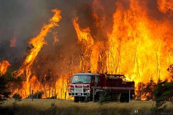
February 9, 2009--A fire truck moves away from out-of-control flames, part of a wildfire about 78 miles (125 kilometers) west of Melbourne, Australia, on Saturday.
|
Ge Linlin, director of National Spatial Information Cooperation Centre, said, "China provides us with visual information. The police, fire-fighting and forest fire prevention departments of Victoria State all used it. They found the information very useful. One of the characteristics of satellite surveillance is wide coverage. Using the information, we can accurately locate fires."
Zhang Junsai, Chinese Ambassador to Australia, said, "This shows the potential for educational and scientific cooperation between China and Australia enjoys a limitless future. I think scientists and governments of both countries should work on it. We should make full use of the latest science and technology to benefit people."
(CCTV February 19, 2009)